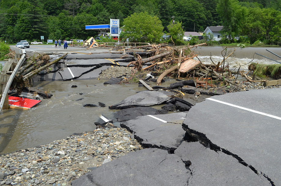
The eastern approach to Routes 14 and 15 at Jackson Bridge was totally washed out due to debris and high water.
by Tyler Molleur, Community Journalist
HARDWICK – Travel back in time… 2011, 1995, 1973. The hills of north-central Vermont have seen their share of floods and flash floods, but the sheer expanse and intensity of this week’s flash flooding pulled elements of all three of these events back into focus.
The landscape on Tuesday morning appeared dramatically changed as the rain came to a close and the sun appeared from behind the clouds. Fields of tall, reedy grass snapped like matchsticks, multiple cars stalled and pushed off of roads, caverns opening up where culverts used to be. This is the evidence that remained after the water rose to catastrophic levels overnight on Monday, leaving towns like Hardwick and Woodbury completely isolated from surrounding resources.
“We are like a little island right now.” Tom Fadden of the Hardwick Fire Department reported to the Lamoille County Sheriff’s Department, as multiple 9-1-1 calls came in to assist with evacuations, stranded cars, and debris floating down the Lamoille River, which crested at record levels in the early morning hours of Tuesday.
Some of the debris seen on the banks of the Lamoille from North Main Street all the way down through the lower part of the village stemmed from the Inn by the River, which all but fell into the river on Monday night. The owners and their guests all made it out of the motel safely before the bank eroded, taking the structure with it.
Hardwick Police Chief Michael Henry advised that residents were asked to evacuate from Granite, Cottage, and Wolcott Streets Monday evening as both the Cooper Brook and Lamoille River continued to rise from excessive rainfall. Molleur Drive in East Hardwick was also evacuated due to flooding from a small creek. An emergency shelter was opened at Hazen Union School Monday afternoon. Volunteers oversaw the shelter, which hosted 40 people overnight. By Tuesday evening, the shelter was able to close as services were restored. Routes 14 and 15 by the Jackson Dam re-opened Tuesday evening, allowing residents to access Morrisville. Route 15 to St. Johnsbury from the intersection with Route 16 became passable Tuesday morning. No one was injured or killed as a result of the destruction and members of the public was at the ready to assist their neighbors.
“The way this community came together in this tragedy was very impressive,” Henry said.
Multiple people came with trucks, tractors, and chainsaws to help clear tree debris out of downtown Hardwick and Route 15E, including members of the Marshfield Volunteer Fire Department.
South of Hardwick, Woodbury also experienced limitations to entry and egress. Fire Chief Paul Cerutti advised that the intensity of the storm easily surpassed other recent legendary floods.
“This is much worse than Irene. This is pretty devastating,” Cerutti said.
Fire apparatus was moved from the station as water rose in the village and through the fire station itself. Up to three and a half feet of water made it into the building, destroying a $15,000 washer and $10,000 dryer for turnout gear. Additionally, specialty equipment for managing forest fires was also lost.
Cerutti is waiting for the water to recede before organizing a work crew to dry the station out and bringing in a structural engineer to determine the building’s stability. Planning also had to occur to summon emergency medical services into town, as both ends of Route 14 to the village were washed out. Cerutti did say town roads were passable via one lane by midday Wednesday.
Other towns that moved their fire apparatus to higher ground due to flooding include Wolcott, Craftsbury, and Hardwick.
In Wolcott, the fire department was assisted by Craftsbury Fire managing multiple incidents, including a washout at Tamarack Brook on Town Hill Road, a rescue on Brook Road, and a tree down on a powerline. Part of a hill just south and west of North Wolcott village was involved in a mudslide.
The National Weather Service reports that five to nearly eight inches of rain fell over our region between the time the storm started Sunday and ended Tuesday. Antecedent moisture existed in the form of torrential rainfall earlier in the week from thunderstorms on July 4, which triggered minor flash flooding in East Hardwick, Walden, and Stannard. Rainfall from repetitive thunderstorms in that event totaled half an inch to an inch and a half of rain by gauge report. One location in North Danville reported 1.3 inches of rain in 30 minutes. These storms were also accompanied by strong downbursts that knocked trees down and cut power to parts of East Hardwick.
This story is developing as more about the extent of storm damage becomes evident. Additional flash flooding is possible from thunderstorms Thursday afternoon and evening and a flash flood watch has been issued. More interviews and details will follow in next week’s edition.


