
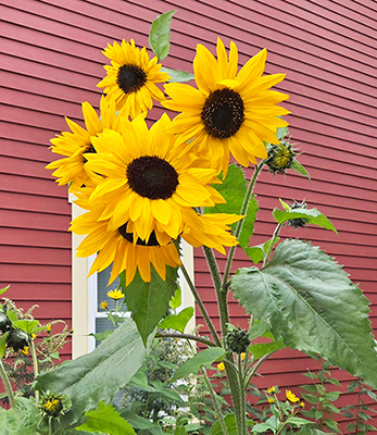


Fall sunflowers glow against a Brush Street barn in Hardwick, September 25.
We’ve been socked in with several days in a row of alternating overcast and breaks of sunshine. Precipitation has largely fallen as light showers, amounting to just under an inch of rainfall over the past week, with temperatures hovering precariously close to freezing. Somehow we’ve managed to avoid accumulating snow in the low and mid-elevations up to this point, with that expected to change this morning as accumulating snow levels reach 1,000 feet or lower. Only an inch or two is expected.
The pinwheeling low bringing us bouts of precipitation gives way to a large dome of high pressure for the rest of the forecast period. This high will bring us mostly sunny conditions and moderating temperatures. A few more clouds are possible as a frontal boundary sags south to the Canadian border on Sunday, but the forecast is largely a nice rubber stamp this week. Here’s how it all pans out:
Wednesday: Mostly cloudy. Scattered rain or snow showers. High: 41. Low: 28.
Thursday: Sunny. High: 52. Low: 33.
Friday: Sunny. High: 59. Low: 35.
Saturday: Sunny. High: 62. Low: 38.
Sunday: Partly sunny. High: 63. Low: 40.

Tyler is our weather reporter and a community journalist. He works as a nurse and EMT, volunteers with Hardwick Rescue and helps to train new EMTs.
