

EAST HARDWICK – Last week lived up to the guarantee of oppressive humidity and excessive heat. Montpelier, as one of our nearest long-term observation stations, tied record highs on both Wednesday and Thursday. Thursday’s high temperature of 90 degrees also occurred the year record-keeping started there in 1949. On Wednesday,[Read More…]
Weather Watch

Dangerous heat and oppressive humidity; cooling some for holiday weekend
EAST HARDWICK – The first week of astronomical summer featured high temperatures in the 70s, with abundant sunshine. Temperatures broke 80 degrees as we wrapped up the weekend. A few showers were mixed in, with about half an inch of accumulation over the course of the week. Temperatures continue to[Read More…]

Some relief from showery weather; seasonable temperatures
EAST HARDWICK – The persistent rainfall has made it challenging to plan any outdoor activities that require things to be dry. Not every day during the previous forecast period was a washout, but the sporadic nature of showers meant that even with some appearances of the sun, a premonition existed[Read More…]
Wednesday rain brings flash floods
VERMONT – Vermont’s flash flood season opened with washed-out roads and a heat advisory right behind it. With heat index values forecast to approach 100 and more thunderstorms possible through the past weekend, state officials say they’re watching both threats at once after storms washed out roads in Hardwick and[Read More…]

Heavy rain Thursday, cool, unsettled most of week
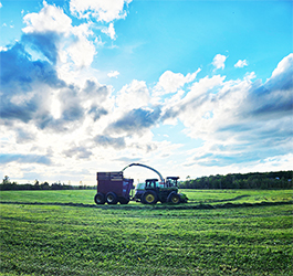
EAST HARDWICK – Prevailing conditions last week put us in a soupy air mass that coincided with some heat. The moisture hanging around, combined with frontal systems that were slow to move resulted in some pockets of heavy rain that added up quickly. Wednesday evening, parts of Hardwick west of[Read More…]

Building heat and humidity through Friday, scattered showers, thunderstorms
HARDWICK – While the weather’s been temperate, precipitation is well above average for the month and we dipped below zero. After a sunny and dry Tuesday, some fog will be possible once again overnight into Wednesday morning. The upcoming forecast period holds chances for scattered showers starting early Wednesday and[Read More…]
Warmer with rainfall respite; unsettled weekend ahead
EAST HARDWICK— Conditions started to dry out on Monday following the passage of a frontal boundary Sunday evening that brought widespread showers and thunderstorms. A spot shower or two was noted on Monday, but sunshine was otherwise abundant with highs reaching the mid-60s. Highs should be in the low 70s[Read More…]
Cooler weather for forecast period; showers again by late weekend
EAST HARDWICK – We continue to outpace the rainfall norms for this month after a week featuring showers and several hours of heavy downpours Wednesday into Thursday. Most rainfall amounts for this storm ranged from an inch and a half to two inches, with Woodbury reporting 2.19 inches and Cabot[Read More…]

Cool and wet conditions persist through the week
EAST HARDWICK – Another weekend with soggy conditions as the prominent feature started later Saturday and persisted through Sunday and Monday, with a total of 1.04 inches of rain. We remain about an inch and a half above normal for the month’s precipitation. Days throughout the forecast period originally projected[Read More…]

Cold, wet for work week, sun and warmth by weekend
EAST HARDWICK – Some heavy rain at the beginning of the forecast period last week brought us ahead of to-date monthly rainfall averages. 1.74 inches of new rain fell between Tuesday, May 5, and Monday, May 11, bringing the monthly total to 1.98 inches, which is 146% of normal as[Read More…]
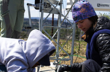
UVM opens Lyndon weather station to fill gaps in flood prediction
LYNDONVILLE – A new University of Vermont extreme weather monitoring station opened in Lyndonville recently, the first in a planned network of monitoring stations to help fill gaps in extreme weather predictions and response. The station will be able to monitor the lead-up to major weather events like flooding or[Read More…]

More unsettled weather for forecast period
EAST HARDWICK— The northeast remains persistent in its cool and wet conditions for the rest of this week, thanks to a large upper-level low situated over Hudson Bay, which continues to pinwheel pieces of energy through the region. In the past several days, we’ve seen showery conditions, with approximately half[Read More…]
