


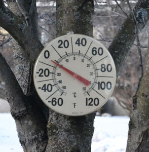
On the morning of February 25 in Hardwick, this thermometer showed a temperature reading of -2 degrees at 6:32 a.m. This is only the second time this winter it has reached a below zero reading.
HARDWICK – What a difference a week makes. Several days of warm temperatures over the past week, combined with light to moderate rainfall continues to erode away at our snowpack which is already minimal for the season. Valley areas report patchy ground cover of snow, with areas from around 1,500 feet reporting six to eight inches of snow depth and areas above 2,000 feet close to 12 to 15 inches of snow depth as of Tuesday. We continued on the roller coaster ride as far as temperatures go, with highs on Thursday topping out near 40°. This was followed by a plummet in temperatures starting Saturday morning, which was noted to be one of the coldest mornings of the season. Single digits below zero were reported area wide. Last week has featured an abundance of sunshine, with very little other precipitation. 0.10-0.20 inches of rain fell during the period, with 1 to 2 inches of snow, divided between the conclusion of our Thursday system and Sunday night’s transition back to near-freezing temperatures.
Clouds are moving in today in the wake of a warm front, which will bring us scattered light precipitation throughout the day. Highs will reach the upper-50s, which puts record high temperatures, like the 55° Montpelier record set in 2018, in jeopardy. However, as is our pattern around here recently, we will see a sharp drop in temperatures overnight tonight as a cold front approaches during the late evening hours with a burst of rain, changing to snow, and a subsequent flash freeze. Temperatures will drop over 30 degrees in the matter of a couple of hours, making the roads snow-covered and potentially icy.
We’re drying out quickly on Thursday, but it will be cold and blustery in the wake of the cold front. Highs will be below normal, but a warming trend will begin Friday into the weekend as high pressure moves to our east and we have more of a southwesterly influence from our winds. A coastal low tries to form off the New England Coast over the weekend, but does not appear to be robust enough to throw much moisture, if any, this far north. Instead, expect some clouds mixed with sunshine to wrap up your weekend as conditions continue to moderate. It looks like a good weekend for a sap run. We’ll have to search for another glimpse of winter further down the road. In the meantime, here’s how the rest of the week pans out:
Wednesday: Cloudy. Light rain throughout the day, with a steady burst of rain changing to snow late evening. Rumbles of thunder in the late evening. Snow accumulation of 1 to 2 inches. Plummeting temperatures with flash freeze likely. High: 59. Low: 5. Wind SW 15 to 20 mph, changing to W and increasing to 20 to 25 mph with gusts to 45 mph. Wind chill values as low as -15 by morning Thursday.
Thursday: Partly cloudy, becoming mostly sunny in the afternoon. Blustery. High: 22. Low: 7. NW winds 15 to 20 mph, with gusts to 35 mph, tapering off by evening. Wind chills as low as 0 possible.
Friday: Mostly sunny. High: 43. Low: 24.
Saturday: Mostly sunny. High; 46. Low: 31.
Sunday: Partly sunny. High: 50. Low: 32.

Tyler is our weather reporter and a community journalist. He works as a nurse and EMT, volunteers with Hardwick Rescue and helps to train new EMTs.


