
HARDWICK, GREENSBORO – Over the past few years, towns in the Lamoille River watershed have spent a great deal of time and money repairing roads, stabilizing riverbanks, replacing culverts and helping residents recover from flood damage.
In many cases, those problems were not caused by water sitting in fields or basements, but by rivers cutting into banks, undermining foundations and changing course. That reality is a big part of why river corridors are receiving more attention now, both in Hardwick and in neighboring towns such as Greensboro.
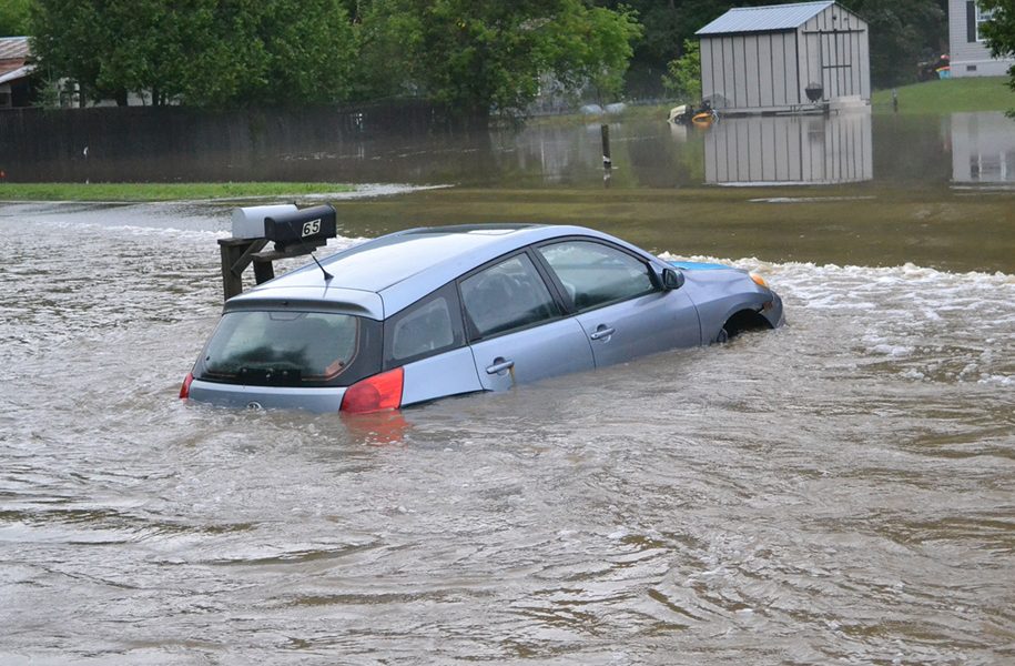
A river corridor is the space a river needs to move over time. You might think of it as a river’s “wiggle room,” the area it needs to adjust, store sediment and find a more stable path down a valley. The size and shape of river corridors vary depending on valley shape, soil and geology, and a river’s slope and width. Rivers are dynamic systems. They do not stay in one place forever, especially during large storms. River corridor maps are intended to show the minimum space a river is likely to need as it naturally adjusts over time.
This is different from floodplain maps, which focus on where water gets deep and spreads during a flood. River corridors focus instead on channel movement and erosion. In recent floods, many of the most serious problems in Hardwick were caused by channel adjustment, not by standing water.
Statewide, roughly 75 percent of flood damage is linked to unstable river channels.
We have seen this locally. Properties such as the Inn by the River and 41 Brush Street in Hardwick were located within the mapped river corridor but outside the FEMA floodplain. These same areas experienced similar damage during the 1973 flood. In both cases, erosion and shifting riverbanks drove the damage. Flood insurance maps did not tell the whole story.
River corridor maps are created by the State of Vermont, not by towns and not by FEMA. They are based on geomorphic studies that look at how rivers behave over time, including slope, sediment, valley shape and historical channel movement. Because those maps affect future planning and permitting, Hardwick has been working with the state to review and refine them using local knowledge and recent flood experience, so they reflect on-the-ground conditions as accurately as possible.
As part of this work, Hardwick is proposing to adopt river corridor regulations in its zoning bylaws.
One question that arises often is whether the proposed rules mean people will no longer be able to fix or improve their property. In most cases, the answer is no. River corridor regulations are not intended to prevent routine maintenance or reasonable improvements. They are meant to limit new investment in places that are very likely to be damaged repeatedly by channel movement, and to avoid putting people in the position of rebuilding repeatedly in areas that are unlikely to remain stable.
Another concern is where permitting decisions will be made in the future. Under Act 121, the Flood Safety Act, the State will begin issuing permits in mapped river corridors by 2028 unless a town requests delegation authority. Towns that adopt and administer their own regulations can retain more local control. Towns that do not may see more decisions handled at the state level.
River corridor policies are also tied to funding. Towns that adopt certain flood-resilience standards are eligible for higher reimbursement rates through Vermont’s Emergency Relief and Assistance Fund, which can reduce the local share of funding after disasters. Many infrastructure grants for bridges, culverts and roads prioritize projects that work with natural river movement rather than against it. Those funding rules affect everyone, whether or not they live near a river.
The purpose of this work is not to punish property owners or take away rights. It is to break a cycle many of us have watched for years: damage, cleanup, temporary fixes, rebuilding and then damage again. That cycle is exhausting, expensive and emotionally draining for the people who live through it.
For Hardwick, river corridor planning connects directly to recent experience. Buyouts, stabilization projects, repeated road repairs and emergency responses have all underscored how important it is to understand what our rivers are doing.
River corridor mapping and regulation are tools to help us make better decisions before the next storm, rather than relearning the same lessons afterward.
It also matters that neighboring towns in the same watershed are working on this at the same time. Rivers do not stop at town lines. What happens upstream and downstream affects everyone. When communities take similar approaches, it strengthens their ability to protect infrastructure and compete for funding.
None of this is simple. That is why Hardwick and Greensboro are working to be transparent about the process and actively seeking public input.
For those interested in learning more or participating in upcoming discussions, the Greensboro Planning Commission will hold a public hearing on river corridors on March 10, 6:30 p.m. at the Greensboro Public Library. A representative from the Vermont Department of Environmental Conservation will be present to answer questions.
A public hearing with the Hardwick Select Board is scheduled for March 19 at 5 p.m in the Hardwick Memorial Building . It will be an opportunity for property owners to ask questions, raise concerns and better understand how the proposed rules would work in practice.
River corridors may sound technical, but the underlying question is familiar to many people in Hardwick and throughout the watershed: How do we reduce repeated damage while keeping our communities livable and affordable? This ongoing work is one attempt to answer that question honestly, based on what we have seen on the ground.
Kristen Leahy serves as the zoning and floodplain administrator and the resilience and adaptation coordinator for the Town of Hardwick.
