


HARDWICK – The Town of Hardwick hosted consultants from engineering firm Vanasse Hangen Brustlin, Inc. (VHB) for a public presentation of alternatives developed as part of a downtown study of pedestrian, vehicular and recreational traffic. Twenty-nine participants joined in-person at the Memorial Building and online, November 5.
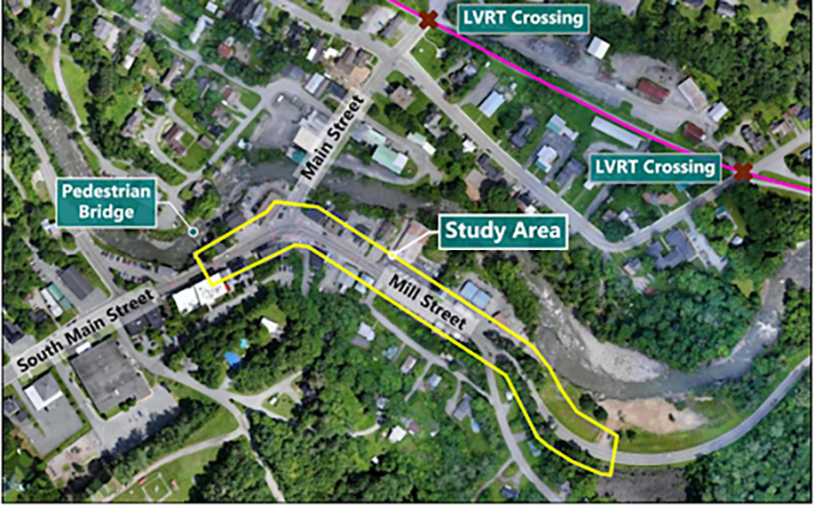
The primary study area runs from South Main Street, above the pedestrian Bridge, onto Mill Street, extending east past the driveway to the former Inn by the River.
courtesy photo
Karen Sentoff, PE, Director of Transportation Systems with VHB, walked attendees through a presentation focusing on improving traffic flow, pedestrian safety and speed management in the downtown corridor.
VHB has been working with Hardwick town staff on the project that began in May this year with a review of existing pedestrian and vehicle traffic in the study area.
A public meeting was held in July to hear resident’s concerns and issues in that area. Between then and now VHB developed the alternatives Sentoff presented November 5.
Sentoff said the purpose of the Hardwick Downtown Study is to create a safe, comfortable environment in the village core; establish a clear transition as one enters the downtown area; improve pedestrian access to community destinations, including businesses and recreational resources; and Improve the transportation connectivity and infrastructure.
“The study is helping clarify what’s possible; what can be done sooner, what will take more engineering and how to phase improvements responsibly,” said Kristen Leahy, Hardwick Zoning and Floodplain Administrator.
“This isn’t about dramatic change. It’s about steady, achievable steps that improve safety and access downtown as funding becomes available.”
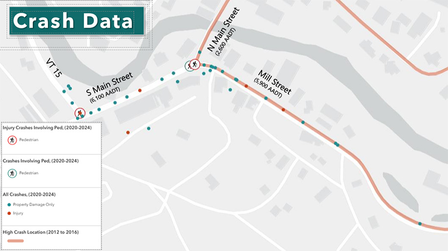
Sentoff identified vehicle speeds through the study area as an issue, with a “desire to better establish transition zones, especially exploring potential improvements for the eastern [Vt. Rte. 15] gateway.”
Other areas needing attention are the intersection of Glenside Avenue with Mill Street; issues at crosswalks, pedestrian safety because of a lack of sidewalks across wide driveways and where streets intersect.
Additionally, the intersection of Mill Street and Main Street presents issues with pedestrian and vehicle safety and traffic patterns.
courtesy photo
And finally, Sentoff identified Post Office access and its driveway as a dangerous area, needing attention.
The following deficiencies highlight the needs of the study area, said Sentoff: The lack of an effective transition zone from a high-speed rural highway to the village center; the non-continuous pedestrian network, with sidewalks interrupted by wide driveways and streets;
and the capacity to handle increased multimodal activity from the Lamoille Valley Rail Trail.
Additional infrastructure deficiencies include vehicle turning movement issues, missing or inadequate crosswalks and impaired stormwater drainage, she said.
Sentoff’s presentation of alternatives described a layered approach with three conceptual alternatives building upon each other. Each offered a menu of possible design elements such as sidewalk continuity and crosswalk enhancements, realignment of the Main Street intersection, traffic-calming measures, including bump-outs, gateway treatments, and improved pedestrian and bicycle connections.
She emphasized that the preferred design will be implemented through a phased approach, allowing the town to pursue incremental construction as state transportation funding becomes available, following an approach that has been successfully used by other Vermont communities, she said.
The third and most comprehensive proposal involves changing the geometry of the Glenside intersection with Mill St. so it becomes more of a T intersection.
Dead ending Sumner Street was suggested as an option that came up at the local concerns meeting because it allows a connected sidewalk along most of Mill Street on the post office side of the street.
The plan might involve some “Welcome to Hardwick” signage at the gateway to Hardwick where the state highway ends and Mill St. begins, said Sentoff.
Attendees, many of whom were residents of the Sumner Street area, offered many suggestions for VHB to consider.
The presentation slides are available in the Planning section of the Town website, and the full meeting is available to be viewed at hctv.us.
The project team will review feedback from the public presentation and identify a preferred alternative for refinement. That draft concept will be presented to the Select Board for review and approval in early 2026. A final Scoping Report is expected to be completed by February 2026. Leahy says she welcomes public input as the project moves toward design.

Paul Fixx is editor of The Hardwick Gazette and lives in Hardwick.


