

HARDWICK – In presentations of Lamoille River models and the analysis of flood mitigation alternatives last week, on Wednesday, representatives with SLR Consulting, Jessica Louisos, Josephine Alling and Doug Osbore shared what they’ve learned about the river’s flow characteristics. By mapping the floodplain, the river channel and its water profiles, the impacts of bridges, culverts and Jackson Dam can now be evaluated and alternatives for flood mitigation explored.
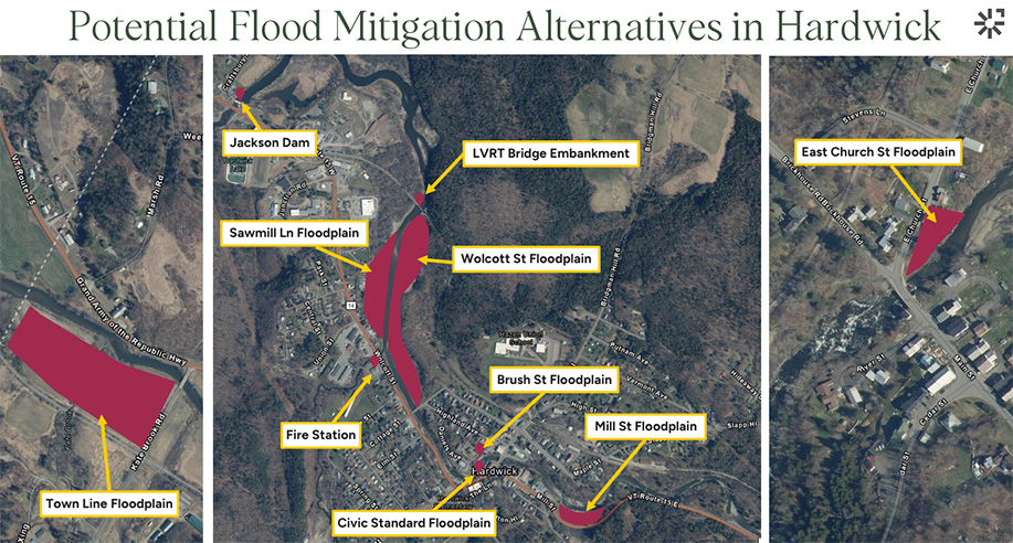
diagram courtesy SLR Consulting
It was the first opportunity for Hardwick residents and businesses to hear what effects there might be if Jackson Dan were to be removed, details of which were presented toward the presentation’s end.
SLR’s study has looked at the Lamoille River watershed from Georgia, near Lake Champlain, upstream through Hardwick. Hardwick’s Zoning & Floodplain Administrator Kristen Leahy was instrumental in having Hardwick added to the study’s initial Lamoille County Area. She said she hopes the upper reaches of the river, into Greensboro Band, can be looked at in the near future.
A midday presentation was well-attended by representatives of riverside property owners and businesses. A similar evening presentation saw more residential property owners in attendance. Between the sessions SLR representatives visited with Hardwick Historical Society President Wiz Dow to look at historical maps and photos of areas align the Lamoille River.
Representatives of Lamoille County Ford and Paul Davis Restoration, properties that saw severe flooding in 2023 and 2024, were at the earlier session.
The modeling allowed the SLC presenters to show the effects of expanding floodplain into areas where buildings have been removed, are planned for future removal or are still being evaluated for possible removal.
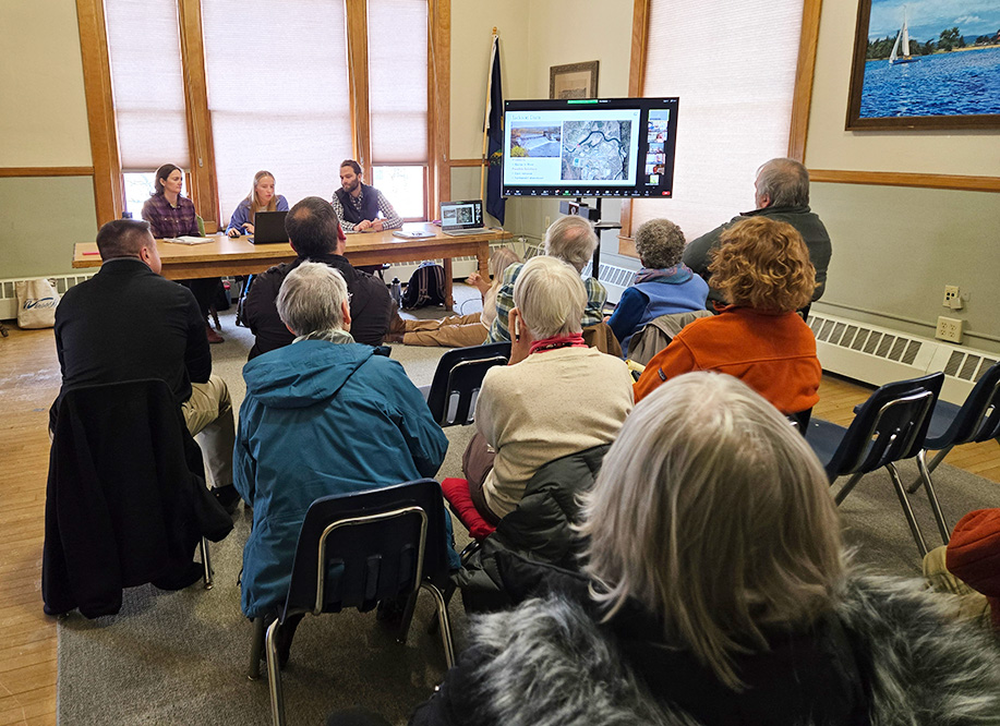
photo by Paul Fixx
River levels at various flood stages allow the models to show depth of flooding and the speed of river flows.
Looking at erosion in East Hardwick and areas created by the demolition following buyouts, led SLR to take a look at what options are possible. Once two properties on the river’s west side, before the Main Street bridge, are removed, the floodplain can be restored in those areas and the slope stabilized, creating areas where water can spread out before reaching the bridge.
They also evaluated lengthening the bridge’s east end.
By combining the two options, SLR expects water levels behind the bridge can be lowered by half a foot in a small flood and as much as two and a half feet in a large flood.
Moving downstream, SLR looked at the site of the former Inn by the River property, which was removed prior to 2024 flooding. Floodplain restoration with slope stabilization and armoring in that area, before the river enters downtown Hardwick, can reduce river velocities in the range of 1 to 5 feet per second, reducing potential flood damage.
Significant benefits are possible along Wolcott Street below the Cottage Street bridge by removing the build-up of silt on the side opposite Wolcott Street since restoration work was done there 40 years ago. Combining that with new floodplain created by the planned removal of the fire station can help limit Wolcott Street flooding in the area where Cooper Brook enters it to manageable levels.
An ongoing conversation is looking at Cooper Brook and flooding in the Granite Street area, but not part of the work this modeling looked at, said Leahy.
Moving downstream a bit farther, SLC identified the area where the Lamoille Valley Rail Trail crosses the river as a constriction that backs up the river and the embankment as a place that prevents the river from rejoining it downstream of the bridge.
Suggestions to lower the trail bed, which could lower the river by as much as a foot and a half in a large flood, will need to involve talks with the Vermont Department of Transportation, said SLR and Leahy.
The long-awaited scientific evaluation of Jackson Dan brought the presentation to a close, before a question and answer period.
The dam presents a problem as it creates a barrier in the river, with possible solutions being dam removal or a permanent drawdown of water levels behind it.
The SLR evaluation showed that the river would be over 6 feet lower at the dam in a small flood and over three in a large one, significantly lowering the danger to the Vt. Rte. 15 bridge and leaving much of the land upstream in the log yard and around Lamoille Valley Ford dry in even a 100 year flood.
The map of that flooding also showed little water across Rte. 15 and none in the water treatment plant lagoons.
SLR representatives emphasized throughout, and as they brought the gatherings to an end, that these are all significant projects, requiring lots of planning and funding. A phased approach can look at the costs and benefits to prioritize projects as funds and community support are available.

Paul Fixx is editor of The Hardwick Gazette and lives in Hardwick.


