


VERMONT – Since its passage in 1970, Act 250 has worked more or less the same way. Broadly speaking, projects triggered review under the law based on how big they were, rather than where they were located, whether that was in the middle of town or on a country road.
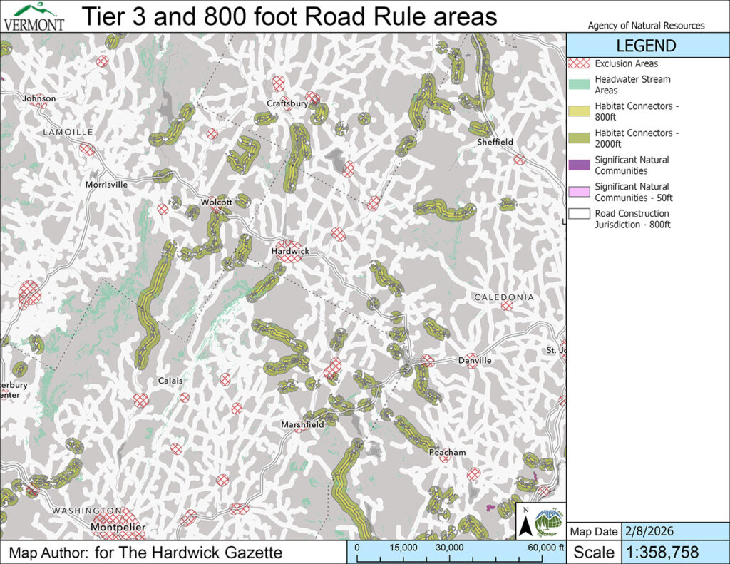
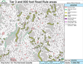
mapping provided by Vermont Agency of Natural Resources.
Act 181 changed that. Its premise: ease the rules in developed areas to promote more homebuilding amid an acute housing shortage, and strengthen the law’s protections over sensitive ecosystems.
Lawmakers mandated a first-of-its-kind statewide land-use map that will dictate where development will be subject to Act 250 scrutiny, and where it won’t be.
The state is categorizing land into three different “tiers” in a complex mapping process that has drawn confusion and controversy. Here’s a progress check on each.
In Tier 1, Act 250 review will be relaxed for housing development. Regional planning commissions and municipalities will decide, with final approval by the Land Use Review Board. Tier 1 is split into two levels. In Tier 1A areas, development will be fully exempt from Act 250. Only Vermont’s largest municipalities with sophisticated local zoning are likely to qualify for Tier 1A: Burlington, South Burlington and Rutland City are all currently preparing to apply. In Tier 1B areas, housing projects that are 50 units or fewer will be exempt from Act 250. Regional planning commissions are currently mapping out where these areas could be.
Five of Vermont’s 11 regional planning commissions have submitted draft maps to the Land Use Review Board, giving us insight into where Tier 1B areas could be. (Only four RPCs were able to share their map data with VTDigger/Vermont Public before publication.)
Some municipalities that qualified for a Tier 1B area have chosen not to opt in to the Act 250 exemption, at least for now. In Chittenden County, Vermont’s population center, a third of the towns the regional planning commission designated as potential Tier 1B areas have chosen not to get the status, including Colchester and Essex.
The Land Use Review Board also gets a chance to weigh in on the proposed Tier 1B areas, and in some cases has advocated for regional planning commissions to shrink them, including in the Rutland County towns of Castleton, Fair Haven, Killington and Poultney. The Land Use Review Board wanted the regional planners to match their 1B areas with traditional town centers “which don’t always align [with] where those communities see future growth,” said Devon Neary, director of the Rutland Regional Planning Commission.
Based on preliminary maps for the entire state, Neary, who also chairs the state association of regional planners, expects 2% to 2.5% of the state’s land to end up falling in Tier 1. That’s less land area than currently falls under current temporary exemptions to Act 250, he said.
Regional planners will continue submitting maps to the Land Use Review Board in the coming months. The board expects to have all initial Tier 1B boundaries set by the end of the year, according to chair Janet Hurley.
The majority of the state’s land is expected to end up in Tier 2. Tier 2 will more or less see Act 250’s current structure continue, with one important change. That one important change is called the “road rule.” When a private entity wants to build a road over 800 feet long in a Tier 2 area, or a combination of roads and driveways longer than 2,000 feet, Act 250 review will kick in. The rule is intended to encourage development close to roads and prevent the fragmentation of forests. The new rule takes effect on July 1. That’s before both the Tier 1 and Tier 3 maps are expected to be complete, which is important because Tier 2 will encompass all land that’s not in one of the other tiers.
Tier 3 will consist of areas deemed “critical natural resources,” where Act 250 review will be automatic for most construction. The Land Use Review Board decides. The Land Use Review Board identified three types of these resources to focus on protecting in Tier 3: rare natural communities, headwater streams in certain areas, and significant habitat connectors along roads. The board has released a draft map of where these areas are and preliminary rules for what kinds of development would trigger review, though they plan to release a heavily amended version in late February, according to Alex Weinhagen, the board member leading the Tier 3 process.
Rural municipal officials and property owners have pushed back against the Land Use Review Board’s Tier 3 map, arguing that too much land is falling into this more restrictive bucket.
“The current draft maps for Tier 3 disproportionately disadvantage Moretown’s potential for housing development in some of the few areas best suited to housing growth,” Karen Horn, the chair of Moretown’s planning commission, wrote to the Land Use Review board in December. The prospect of laying on additional state review on areas where housing is encouraged locally “is beyond demoralizing,” Horn added.
A resident on Wheelerville Road in Mendon wrote to the Land Use Review Board arguing that the entirety of her road should not be considered Tier 3 as a habitat connector, since wildlife use nearby intact forests to move around.
Weinhagen is sympathetic to these concerns, he said, adding that the next version of the Tier 3 map “will show much tighter areas.”
He also wants the board to consider exempting “very small development” in Tier 3 areas, like homesteads on half an acre. Tier 3 jurisdiction is slated to kick in at the end of 2026.
This story, by Report for America corps member Carly Berlin, was produced through a partnership between VTDigger and Vermont Public.


