

VERMONT − On July 25, Vermont Emergency Management (VEM) explained the difference between a Weather Watch and a Weather Warning from the National Weather Service, with pizza as an example. A Watch means all the ingredients are present but there’s no pizza. Conditions are favorable for something to happen —[Read More…]
Weather Watch

Roller Coaster Ride of Temperatures; Seasonable by Weekend
EAST HARDWICK – Last week’s temperatures peaked in the upper 80s and low 90s on Thursday. The Route 14 weather station just west of Hardwick Lake reported a heat index of 96 degrees by afternoon. This heat occurred ahead of a cold front that brought multiple rounds of thunderstorms with[Read More…]
Uneventful and cooler forecast for this week
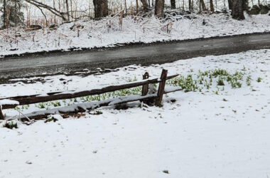
EAST HARDWICK – Our forecast period last week included a dramatic shift in temperatures. Highs in the upper-60s on Saturday under full sunshine and a south breeze changed to a cloudy Sunday, with temperatures falling to the 30s and accumulating snow across the region. 2.5 inches of new snow fell[Read More…]

Showers, Thunderstorms Break Heat; Sunny Start to the Weekend
EAST HARDWICK – Conditions remained largely hot and humid this past week as we remained under the influence of an upper-level low with multiple waves serving as the focus for slow-moving scattered showers and thunderstorms. The variability in thunderstorm location and rainfall amounts is reflected in this week’s rainfall observations,[Read More…]

More Rain in the Forecast, Saturday Looks Sunny
EAST HARDWICK – Zero: that’s the precipitation amount observed at the East Hardwick rain gauge this weekend, marking an end to the persistently wet weather of several Saturdays and Sundays the past few months. It’s worth noting the weekends recently have still afforded some window of fair weather, but with[Read More…]

Fourth of July Weekend Starts Mild and Sunny; Some Rain Sunday
EAST HARDWICK – Part-two of the heat continued after the last week’s publishing deadline and multiple observing stations saw record highs on June 24. A record high temperature of 93 degrees was set in Montpelier, shattering the old record of 89 set in 1995. Similarly, St. Johnsbury broke its old[Read More…]

Heat Departing; Another Split Weekend for Precipitation
EAST HARDWICK – Much of Vermont is in the wake of a short burst of extreme heat, which saw temperatures reaching the 90s for two days in a row. Although temperatures stopped short of qualifying this event as a heat wave (three days of 90 degree-plus highs), humidity during the[Read More…]

Rounds of Thunderstorms; Hot Weather on the Horizon
EAST HARDWICK – A little bit of a flip occurred this week, with the weekend largely dry and sunny with some showers scattered throughout the rest of the forecast period. We still stopped short of having a completely rain-free weekend, with a couple of local observing stations reporting a few[Read More…]
Showers Interspersed Among Sun, Seasonal Temperatures
EAST HARDWICK – It was a little warmer and a little sunnier this past week as clouds were noted to break a little both Saturday and Sunday, although we still had to contend with some showers. The persistence of precipitation seems to be waning as we enter into June and[Read More…]
Some Sun, Some Rain; Much Warmer This Week
EAST HARDWICK – Rain was relentless in May, the observing station in East Hardwick saw 4.40 inches, with the normal for the month being 3.83 inches. The heavy rain from Saturday’s coastal storm did not count into this total because observations are taken in the morning, meaning an additional 1.02[Read More…]

Rain, Rain, Here to Stay…
EAST HARDWICK – After another round of dreary and soggy conditions, Memorial Day weekend closed out Monday with the first 24-hour break in rainfall seen in over 10 days. Precipitation this forecast period was lighter than the previous due to its showery nature. It amounted to a widespread eight-tenths of[Read More…]

Cool, Wet Weather Persists One More Week
EAST HARDWICK – The weather pattern shifted significantly over the last week with highs in the 80s dipping into the mid-50s to low-60s by the conclusion of the weekend. This is thanks in part to a low-pressure system that arrived Friday and Saturday, bringing several rounds of heavy rain and[Read More…]


